Click for weather forecast
Site Map
- Home
- Balboa Island Blog
- Online Store
- Balboa Island and Local Events
- Real Estate for Sale
- Links
- What's On The Island
- Apparel/Accessories
- Art/Home/Design
- Community Organizations
- Gifts/Specialty Shops
- Jewelry
- Real Estate Professionals
- Restaurants/Fun Food
- Services
- Rentals
- New Resident Information
- Media Contact Information
- Pictures
- 2011 Balboa Island Parade
- 2009 Balboa Island Parade
- 2007 Balboa Island Parade
- Balboa Island Parade 2006
- 2005 Balboa Island Parade
- 2004 Balboa Island Parade
- 2000 Balboa Island Parade
- 1999 Balboa Island Parade
- Balboa Island Pictures
- Local Specials
- Fun Facts
- How To Find Us
- Lost and Found
Connect with Balboa Island
Balboa Island Questions?
- Contact Carolyn Carr at
Island Breeze Newsletters
- October, 2016
- March, 2016
- December, 2015
- September, 2015
- June, 2015
- April, 2015
- March, 2015
- December, 2014
- October, 2014
- September, 2014
- June, 2014
- April, 2014
- February, 2014
- December, 2013
- September, 2013
- July, 2013
- April, 2013
- March, 2013
- November, 2012
- July, 2012
- April, 2012
- March, 2012
- November, 2011
- October, 2011
- June, 2011
- April, 2011
- November, 2010
- September, 2010
- April, 2010
- March, 2010
- December, 2009
- October, 2009
- September, 2009
- July, 2009
- May, 2009
- April, 2009
- March, 2009
- November, 2008
- October, 2008
- August, 2008
- June, 2008
- April, 2008
- March, 2008
- January, 2008
- November, 2007
- October, 2007
- September, 2007
- August, 2007
- June, 2007
- May, 2007
- April, 2007
- March, 2007
- December, 2006
- October, 2006
- July, 2006
How to Find Us
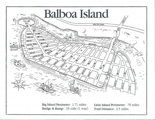
Here is a Fun Map of Balboa Island That you can Download -
Balboa_Island_Map_1.pdf
For Driving Directions to Balboa Island please Click MAP QUEST and enter your starting location.
Well, we are
... in the United States of America
... in the State of California
... in the County of Orange (home to Disneyland)
... in the City of Newport Beach
... in the Pacific Ocean nestled between
... the Balboa Peninsula and Pacific Coast Highway (Highway 1)
1. Directions from Los Angeles International Airport (LAX): (or for Mapquest, put in the address 100 Marine Avenue, Balboa Island, CA 92662)
Take the 405 Freeway South to the Jamboree Exit.
Take Jamboree Boulevard west (towards the beach) for approximately 5 miles till it crosses Pacific Coast Highway, down a hill and ends on Balboa Island!
2. Directions from John Wayne/Orange County Airport (SNA):
Exit the Airport onto McArthur turning right out of the Airport
Take McArthur to Jamboree and turn Right.
Take Jamboree for approximately 3 miles till it crosses Pacific Coast Highway, goes down the hill and goes over the Balboa Island Bridge and ends on Balboa Island!
3. Directions from the San Diego Area:1 (or for Mapquest, put in the address 100 Marine Avenue, Balboa Island, CA 92662)
Take the 405 Freeway North to the Jamboree Exit (after you cross the 55 Freeway).
Take Jamboree west (towards the beach) for approximately 5 miles till it crosses Pacific Coast Highway, goes down a hill and ends on Balboa Island!
4. Directions if you are sailing in to see us:
33 degrees, 36 hours and 2 minutes north; 117 degrees, 53 hours west.
Download a map of the area 13k (you can print it out, too!)
